BLOG • September 15, 2026
Can satellites spot illicit crops from space? Kuva Space shows hyperspectral imaging and in-house AI models boost detection at scale

From orbit, an opium poppy field does not necessarily look very different from a field growing a legal crop. That makes illicit crop monitoring a difficult Earth observation problem, particularly across large, remote or inaccessible regions where field verification is costly or impossible.
Kuva Space recently conducted a pilot with a major European security stakeholder to test whether hyperspectral satellite imagery and in-house AI models could improve that process.
Between January and June 2026, Kuva Space’s Hyperfield-1 satellites collected 363 hyperspectral images representing 648,450 km² of total image coverage across the Helmand region in Afghanistan.
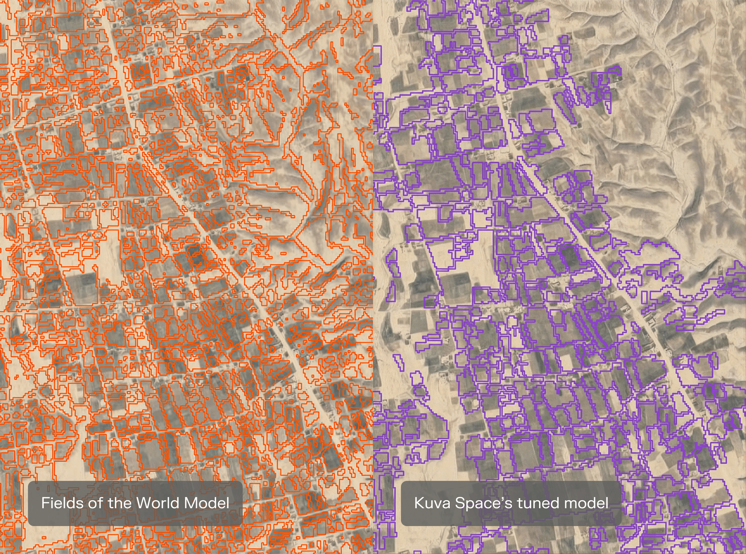
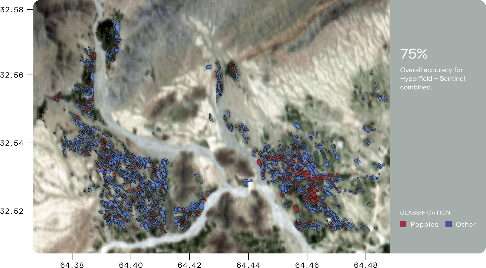
The data was combined with Copernicus Sentinel-2 imagery and AI-based classification. Because precise field boundaries were not available for Afghanistan, Kuva Space used a separate parcel delineation model – fine-tuned on Sentinel-2 data to Afghanistan's small, desert-mixed fields. The resulting model achieved 75% overall accuracy, compared with 71% using Sentinel-2 alone, while reducing false positives.
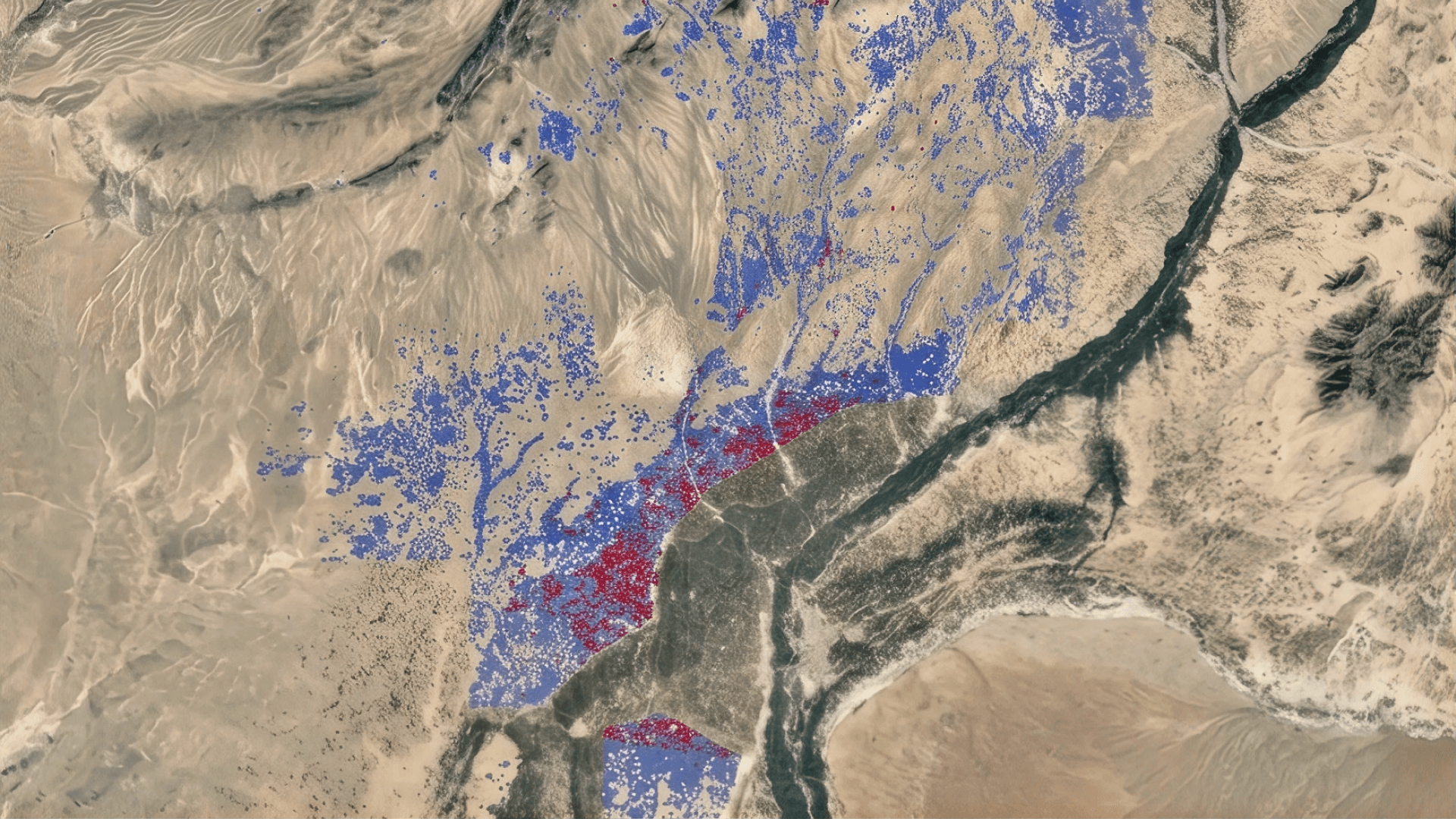
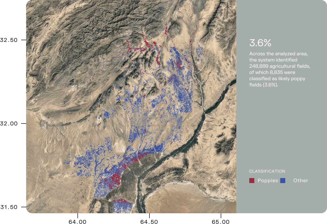
Across the analyzed area, the system identified 248,889 agricultural fields and classified 8,835 as likely poppy fields, corresponding to approximately 3.6% of the identified cultivated area. The aim is not to replace verification, but to narrow the search: helping analysts identify where costly high-resolution imagery and further investigation are most likely to be worthwhile.
Seeing what conventional satellite imagery misses
Multispectral satellites such as Sentinel-2 are widely used to monitor agriculture and land cover. But distinguishing one crop from another can be considerably harder.
Hyperspectral sensors measure reflected light across many narrow spectral bands, revealing subtle differences in vegetation linked to characteristics such as chlorophyll, water content and pigmentation.
This creates a richer spectral signature than conventional satellite imagery alone cannot provide.
For illicit crop monitoring, that matters because poppy can be grown in small or heterogeneous fields and can resemble legal crops at different stages of the growing season. Cloud contamination, terrain shadows, and rapid changes in vegetation over time can make reliable identification more difficult still.
In the pilot, combining Kuva Space’s hyperspectral Hyperfield-1 data with Sentinel-2 reduced false positives compared with either source alone.
That has a direct operational benefit. Every false positive can result in additional imagery acquisition and analyst time. A more selective screening layer allows those resources to be concentrated on a smaller number of higher-probability areas.
Satellite monitoring has traditionally forced a trade-off between covering very large areas and seeing enough detail to identify what is actually growing there. Hyperspectral data starts to close that gap.
Building the model without relying on field access
Reliable reference data is essential to train and validate any crop-detection model.
For the Afghanistan pilot, poppy reference fields were identified using a combination of very-high-resolution (VHR) satellite imagery and Sentinel-2 observations over time, using a workflow similar to that reported by UNODC for poppy monitoring in Afghanistan.
Rather than relying on a single image, analysts examined how candidate fields changed during the growing season, including differences in harvest timing. Poppy in the target regions is typically harvested earlier than several visually similar crops, providing an additional clue for classification.
Accurate field boundaries were also unavailable across much of the study area. Kuva Space therefore generated its own parcel map using a deep-learning field-delineation model adapted to Afghanistan’s small and heterogeneous agricultural plots.
The result was a parcel-level system designed to identify likely poppy fields rather than simply flagging individual pixels.
Combining hyperspectral data and AI
Kuva Space built the hyperspectral classifier on its HF-1 foundation model, pre-trained on more than 1.2 million Hyperfield image patches.
The model learns spectral and spatial patterns from satellite imagery, then applies them to downstream tasks such as vegetation classification.
For the pilot, Kuva Space tested separate Hyperfield and Sentinel-2 classifiers before combining their predictions. The strongest-performing model classified a parcel as poppy when both sources agreed.
The combined model reached 75% overall accuracy, outperforming Sentinel-2 alone at 71% and reducing false positives from the individual models.
In a geolocation test using three Hyperfield images overlapping the Pléiades VHR imagery used for poppy identification, Kuva Space achieved an average CE90 of 21.75 meters, equivalent to 0.87 Hyperfield pixels. This was sufficient to align detections with the correct field locations even in the small, fragmented agricultural parcels typical of Afghanistan.
All agreed pilot KPIs were met, including targets for classification, geolocation, processing speed, and memory consumption.
A shifting global opium map
The need for scalable monitoring is also changing geographically. According to the UN’s 2026 World Drug Report, Afghanistan’s opium production remains dramatically below pre-ban levels, while poppy cultivation in Myanmar increased 17% in 2025, making it the world’s largest opium producer.
As cultivation shifts between regions, monitoring systems need to be able to cover large territories and adapt quickly, particularly where physical access is limited.
Kuva Space’s approach is designed for that type of problem: using hyperspectral satellites and AI to screen large areas first, then directing more detailed analysis to the locations most likely to warrant further investigation.
By detecting differences in vegetation that conventional imagery can miss, we can screen entire regions and focus the most expensive analysis on a much smaller set of high-probability areas. That changes both the economics and the scalability of illicit crop monitoring.
From pilot to operational monitoring
One of the key findings from the pilot was that a model trained using a limited reference area could be applied across a substantially larger part of Helmand without requiring exhaustive field labeling across the whole region.
Across the analyzed coverage, Kuva Space's system identified 248,889 agricultural fields, of which 8,835 were classified as likely poppy fields. The highest concentrations of detections appeared in the mountainous areas of northern Helmand and around the more densely farmed areas near Lashkar Gah.
The resulting estimates and regional patterns were broadly consistent with trends reported in recent UNODC poppy reports.
These are model predictions rather than independently verified detections. Their value lies in prioritisation: identifying where additional intelligence resources are most likely to be useful.
The same approach could potentially be adapted to other opium-producing regions, including Myanmar, as well as to other illicit crops such as coca in South America.
More broadly, hyperspectral Earth observation offers a way to distinguish vegetation based not only on how it looks from space, but on its underlying spectral characteristics.
For illicit crop monitoring, that can turn an enormous search area into a much more focused intelligence problem.