BLOG • June 1, 2026
What ship tracking missed in the Strait of Hormuz

Kuva Space’s hyperspectral satellite analysis shows gaps in AIS-based vessel tracking in one of the world’s most strategically sensitive maritime chokepoints.
- Kuva Space compared what ships broadcast with what satellites could see. In multiple satellite images from the Strait of Hormuz, Kuva Space found vessels that were visible from space but missing from AIS-based tracking, the system commonly used to monitor vessel location and movement.
- The gap was not minor. On March 29, Kuva Space detected 360 vessels in one image. Only 12 had matching AIS signals.
- The finding shows a visibility gap, not proof of wrongdoing. A missing AIS match does not identify a vessel or prove intent. But in a chokepoint like the Strait of Hormuz, it shows why AIS alone may not provide a complete picture of maritime activity.
Kuva Space detected vessels visible from space but absent from AIS-based tracking across several satellite-imagery scenes in one of the world’s most strategically important maritime chokepoints.
Kuva Space analyzed hyperspectral satellite imagery from the Strait of Hormuz and identified repeated vessel activity without matching Automatic Identification System signals across several dates before, during, and after a February 28 maritime security incident.
The analysis highlights a gap between two different views of maritime activity: what is visible through conventional ship-tracking systems and what can be observed directly from space.
AIS is widely used to track vessel identity, position, speed, and course. It remains a critical tool for maritime safety, commercial shipping, and situational awareness. But AIS-based tracking is not a complete record of everything happening at sea. Signals may be absent for technical, operational, or intentional reasons, and in contested or crisis-sensitive waters, that limitation can become significant.
Kuva Space’s analysis shows that in several captured scenes around the Strait of Hormuz, vessels were visible in satellite imagery even though they did not appear with corresponding AIS matches.
AIS can make maritime activity look more transparent than it really is. What we saw in the Strait of Hormuz is that vessels can remain visible from space even when they do not appear in conventional tracking. In a crisis-sensitive chokepoint, that gap matters.
Vessel detections across multiple dates
Kuva Space analyzed imagery captured on February 21, February 28, March 5, March 14, March 28, and March 29, 2026, over several locations in and around the Strait of Hormuz.
The company applied its in-house AI-based vessel-detection model to the imagery and compared the detections against external AIS data. This allowed Kuva Space to distinguish between vessels with matching AIS signals and vessels detected from space without corresponding AIS matches.
The analysis found:
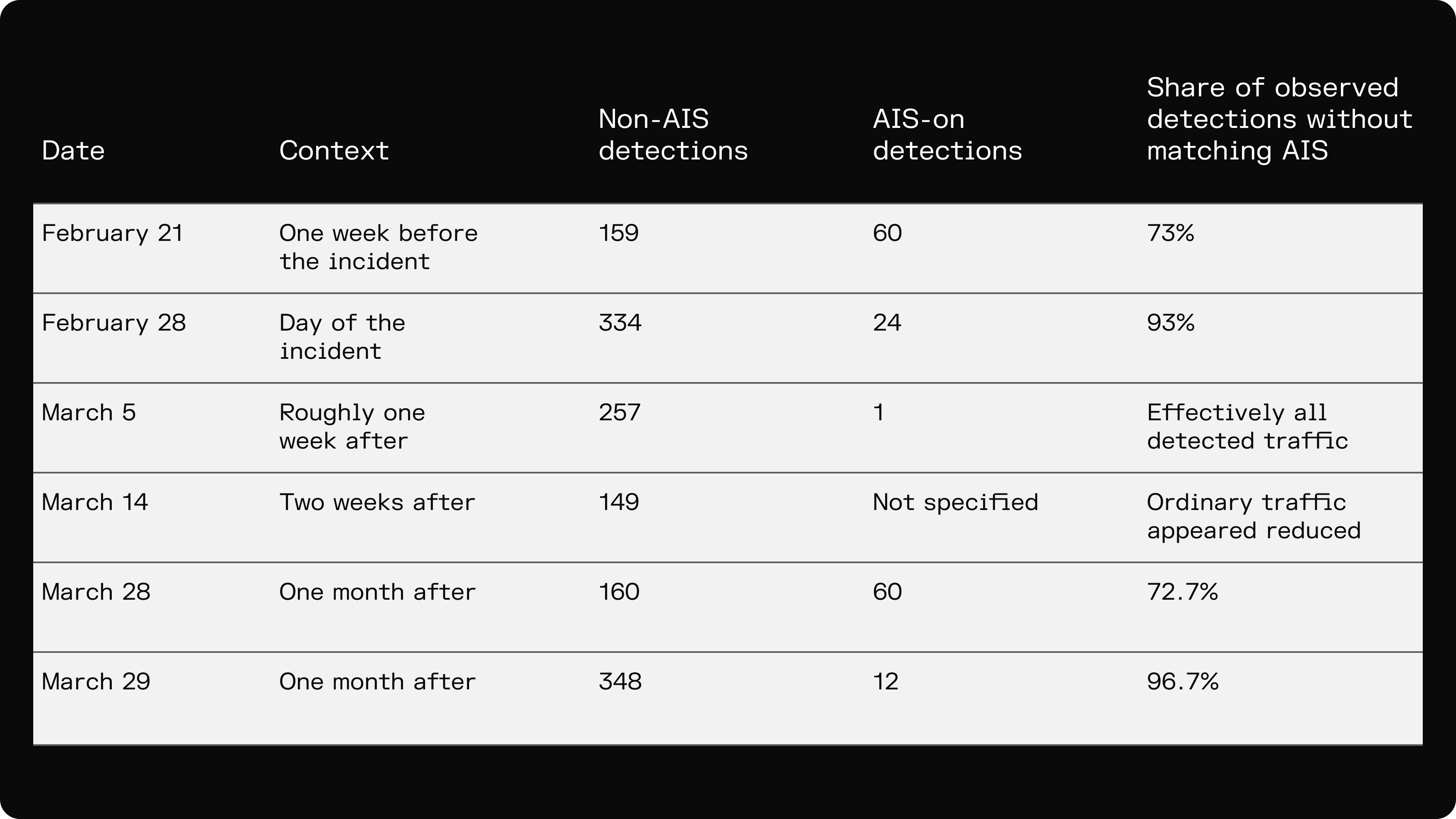
The findings do not show a complete halt in maritime activity after the February 28 incident. Instead, they suggest that vessel activity continued to be visible from space while AIS-based tracking captured only part of what was present in the imagery.
That distinction is important. If maritime activity is assessed only through AIS-based systems, some vessels present in the operating environment may not be reflected in the public tracking picture.
Why non-AIS detections require careful interpretation
A vessel detected without a matching AIS signal should not automatically be interpreted as suspicious. There are several possible explanations for a non-AIS detection, including technical issues, reception gaps, operational discretion, fishing activity, piracy risk, military sensitivity, sanctions evasion, smuggling, or other factors.
The analysis does not identify individual vessels, determine intent, or link specific detections to the February 28 incident.
Its significance is more limited, but still operationally relevant: it shows where conventional ship-tracking data may provide an incomplete picture of maritime activity.
In the Strait of Hormuz, that matters because the waterway is tied to global energy flows, naval operations, sanctions enforcement, shipping insurance, commercial routing, and regional security. In such an environment, incomplete visibility can shape how risk is assessed.
How the analysis was conducted
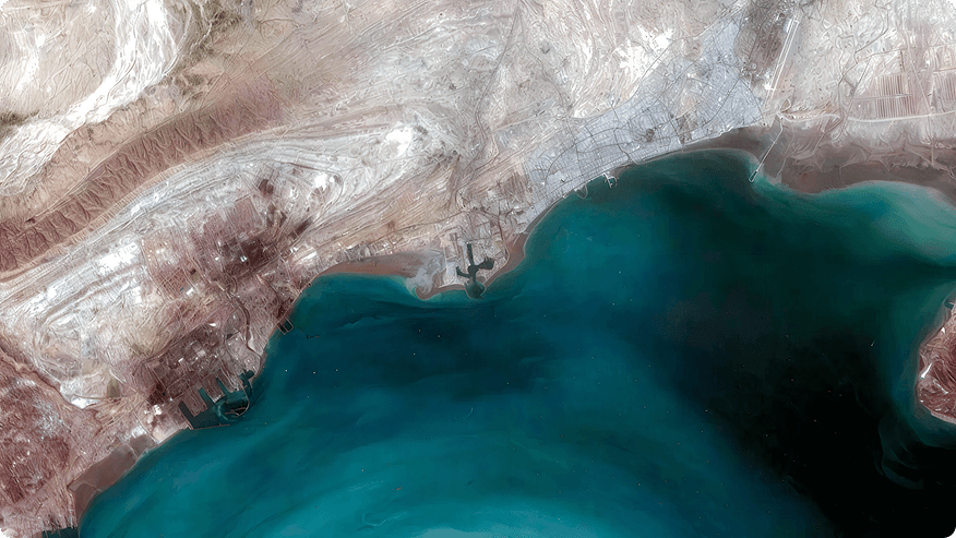
Kuva Space used hyperspectral satellite imagery captured across several dates and locations in and around the Strait of Hormuz.
The company’s AI-based vessel-detection model was applied to identify vessels in the imagery. The detections align cleanly with other sensors (Sentinel-1, Sentinel-2, and Landsat). External AIS data was then overlaid against those detections to determine which vessels had matching AIS signals and which did not.
In this analysis, a “non-AIS detection” refers to a vessel detected in Kuva Space imagery that did not have a matching AIS signal in the external AIS data overlay.
Kuva Space said its model is trained on hundreds of images and thousands of annotated vessels and produces confidence indicators that the detected object is a vessel.
What the findings show
The analysis should be read as a series of hyperspectral snapshots across several dates and locations. It is not a continuous time series of the same scene and does not reconstruct all maritime activity in the Strait of Hormuz.
The findings do not attribute intent to any vessel. They also do not establish that non-AIS detections were connected to the February 28 incident.
What they do show is that satellite-based vessel detection can provide an additional observation layer where AIS-based tracking is incomplete. By comparing what appears in satellite imagery with what appears in AIS data, Kuva Space can identify gaps between tracked activity and observed activity.
For defense, security, commercial shipping, energy, and intelligence organizations, that additional layer can support a more complete understanding of activity in high-priority maritime areas.
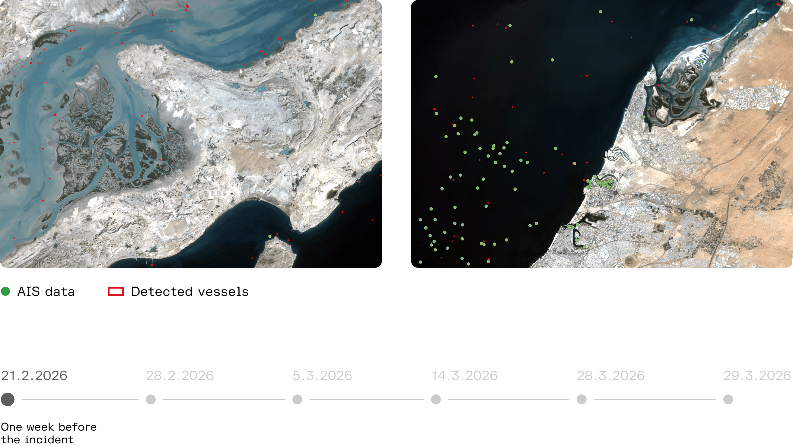
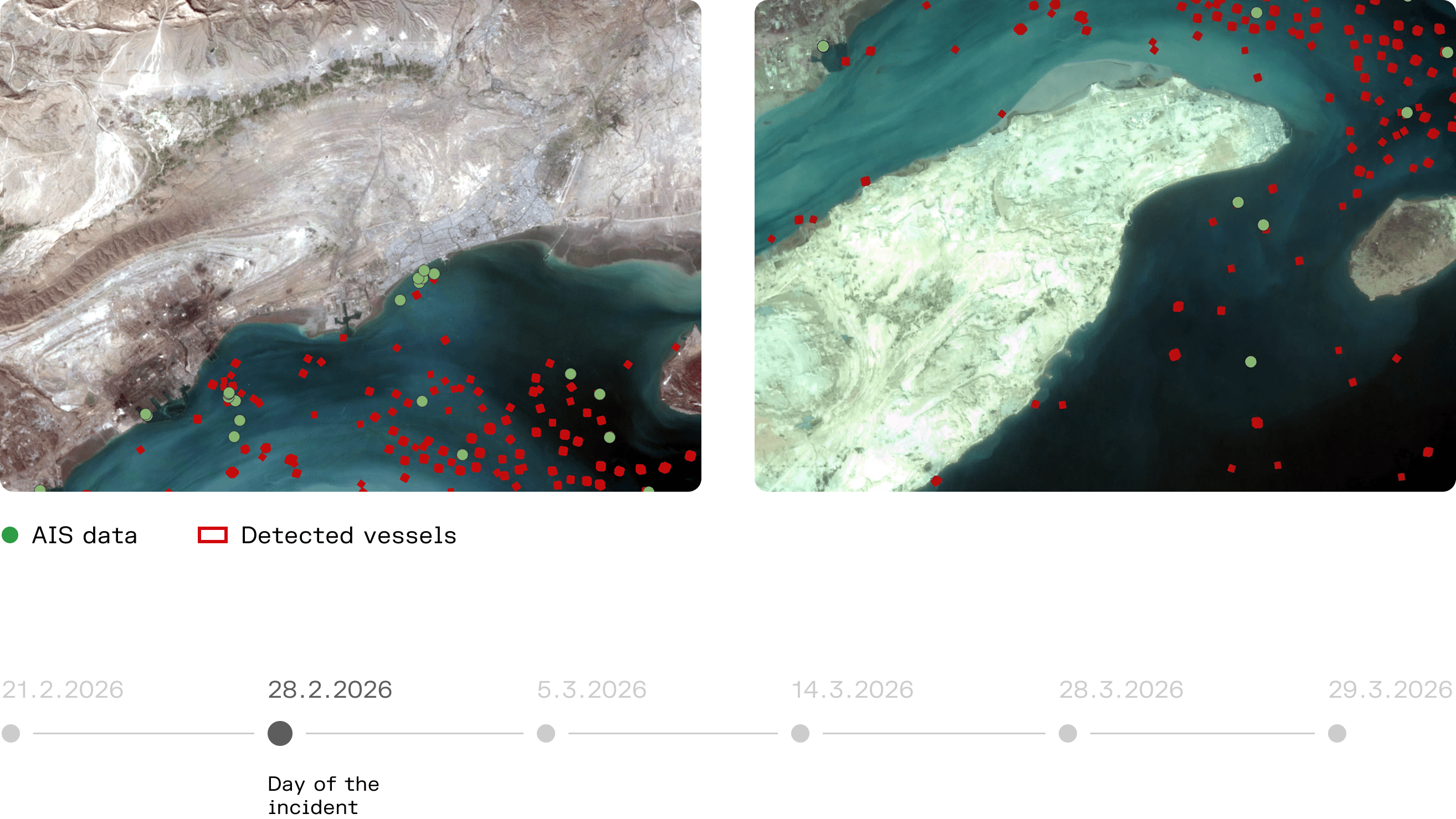
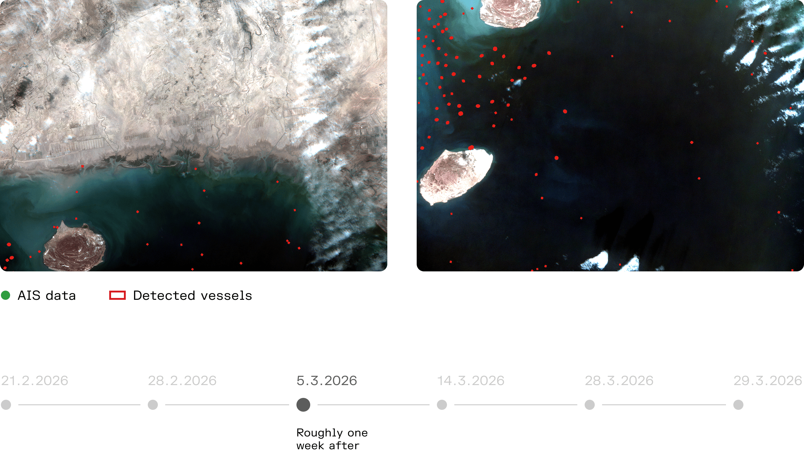
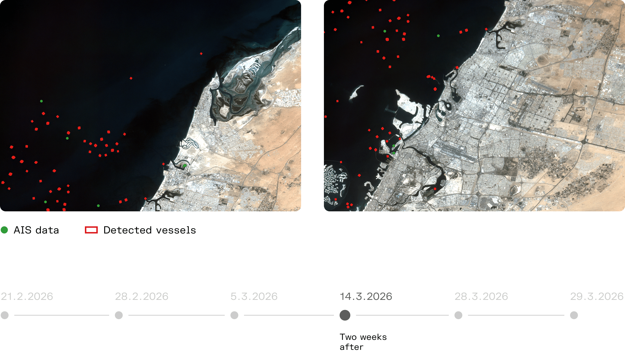
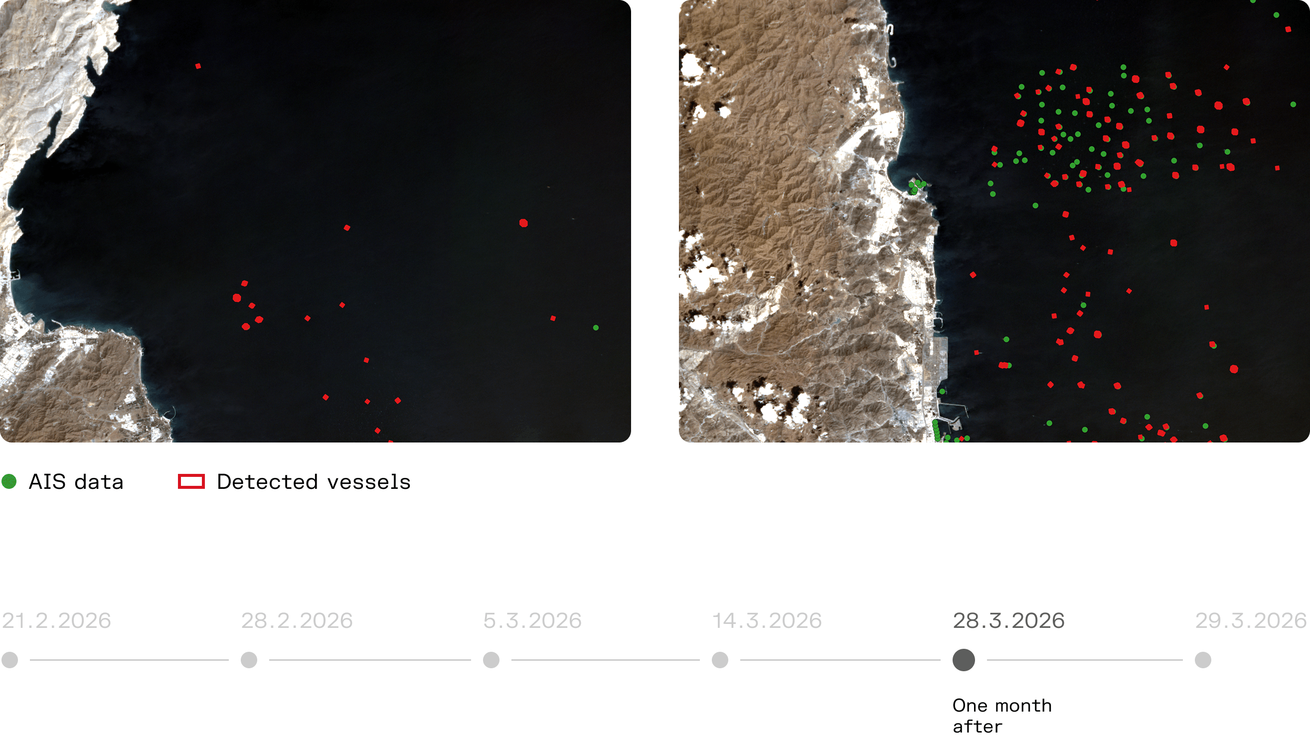
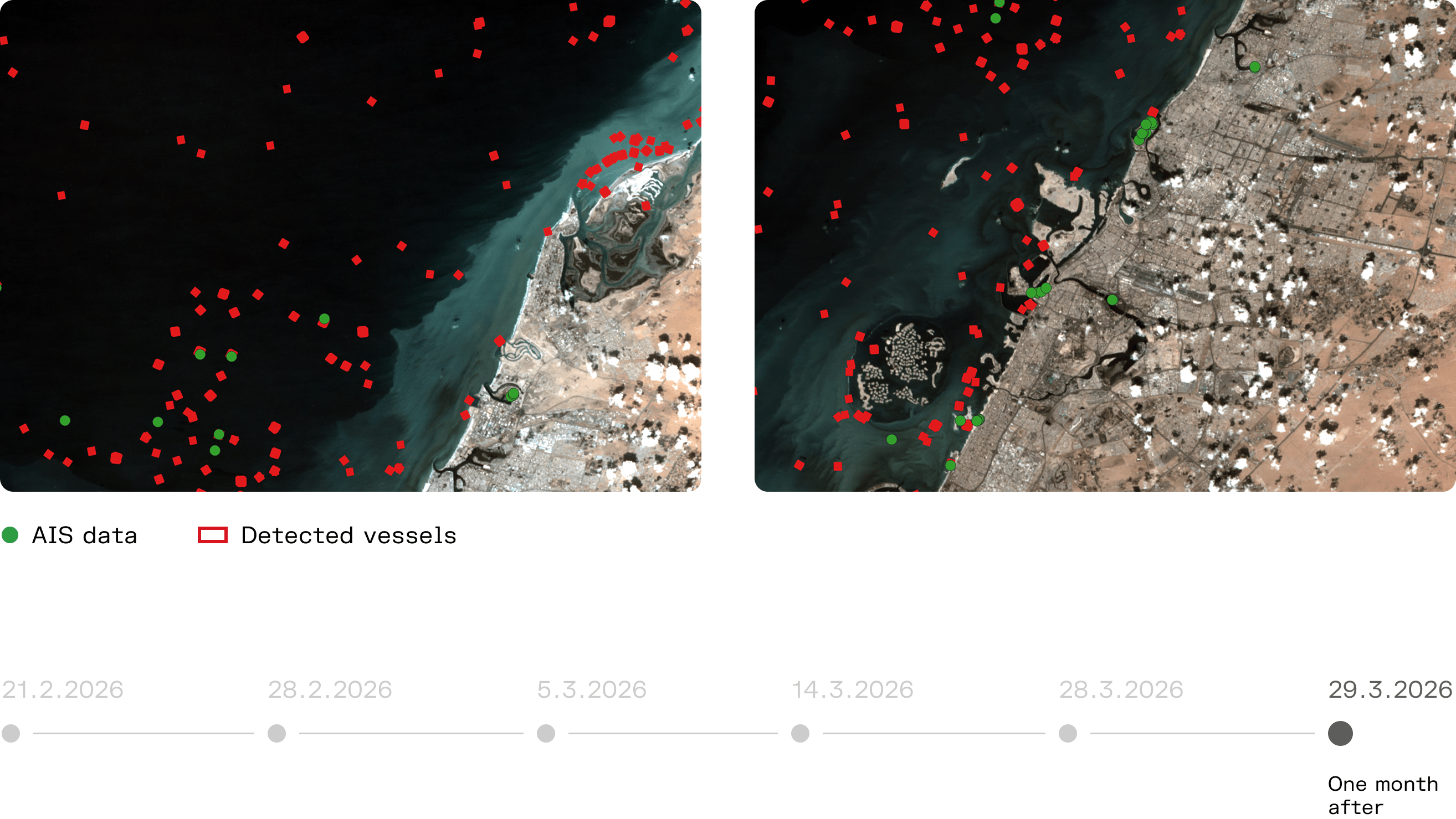
Selected satellite images from the analysis
An additional layer of maritime awareness
The Strait of Hormuz is one of the world’s most closely monitored maritime corridors. However, close monitoring does not necessarily mean complete visibility.
AIS remains an essential source of maritime information. Satellite-based vessel detection adds a separate layer: it can show vessels that are physically present, even when they are not reflected in AIS-based tracking.
Kuva Space’s analysis demonstrates how hyperspectral satellite imagery and AI-based analytics can support maritime domain awareness in areas where visibility is strategically important and conventional tracking data may be incomplete.